This is Leslie VonHolten traveling through the High Plains of Kansas, with another HPPR Radio Readers Book Byte.
I love the metaphor of rivers when we consider our life experiences, the way our days and our stories ebb and flow. Some spots are rough, too fast for us to steer the kayak. Others are languid, slow and easy. And like life, we never know what is around the bend.
This is why I so enjoyed Max McCoy’s book Elevations. It is a deep map-style travelogue of the best kind: part exploration, part adventure, and a good amount of honest self-reflection. His “writer’s voice” guides us easily as he canoes, walks, and drives the length of what we here in Kansas call the Ark-KANSAS River. These are areas I thought I knew well, but Elevations taught me to look again.
For example: For years as I drove Interstate 25 in Colorado, I passed the site of the Ludlow Massacre, not knowing the tragedy that happened there, or even that the High Plains witnessed labor strikes and murderous violence. That was a story I had unconsciously associated with the coal mines of West Virginia. The book inspired me to stop at the site this summer and consider that terrible scene way back in 1914. And to consider how history always has more to show us.
Going back further in time, McCoy reveals another nearby tragedy: The Sand Creek Massacre, where Cheyenne and Arapahoe people were murdered by Colonel Chivington’s soldiers in 1864. As I visited this national historic site, I realized how important it is to read about history. But it is also important, when we can, to walk the ground where events like Sand Creek happened. It deepens your empathy and changes the way you look at the land around you.
Elevations has lighter moments, too. Including one that helped me laugh at myself. To better understand the experience of famous explorer Zebulon Pike, McCoy spends Christmas Eve cold in a tent. Reading this, I had to remember a failed camping trip I had done in the same mountains, at 11,000 feet altitude near Leadville. Whereas McCoy and Pike camped in snow, in December, I camped in July. I had no snow but plenty of rain. And in my defense, the temps did go below freezing at night. But I also had technical layers and good camping equipment. I am humbled, and rather dispirited by my lack of pioneer grit.
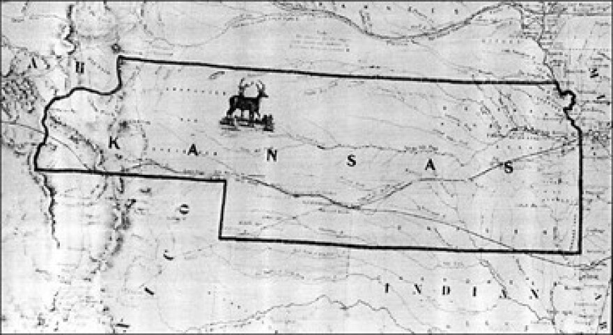
Something I did consider on that camping trip, and when I read Elevations, is how boundaries shape us and determine often what we know. While at the headwaters of the Arkansas River near Leadville, I wondered how my life would be different if the boundaries of Territorial Kansas were the same boundaries as Kansas today. The territorial map of my home state stretched to the Rocky Mountains. What to me are eastern Colorado stories would have been Kansas stories. I probably would have been more familiar with them.
(Also, one of the longest running Supreme Court cases, Kansas v. Colorado, a century-long battle of Arkansas water rights, would be moot if the headwaters were in Kansas territory.)
This deep map approach to nature writing, to human geography and stories that echo in each traveled footstep, was made famous in writer’s circles by William Least Heat Moon, when he wrote about another rather unassuming area in the Midwest: Chase County, Kansas. But like a river, McCoy’s book is more fluid. He builds his deep map with an appreciation and awe of the environment, and the stories of place that connect people to the earth and to each other across time.
This is Radio Reader Leslie VonHolten hoping you will join us in reading Elevations: A Personal Exploration of the Arkansas River by Max McCoy. It’s a good book. Find more at HPPR.org, or Like us on Facebook.


![”THE GRAPES OF WRATH (1939; awarded the Pulitzer Prize for fiction in 1940). Inevitably also 1962 Nobel Literature Laureate's tale of the migrating Joad family is surely the most emblematic novel of the American Great Depression. This [collector’s] pristine copy of the first state carries with it the exceedingly rare advance review slip with an author painting by Stjernstrom, first appearing as the frontispiece for the Lewis Gannett's edition and also the1939 "’John Steinbeck: Personal and Bibliographical Notes.’"](https://npr.brightspotcdn.com/dims4/default/e6680cb/2147483647/strip/true/crop/728x406+0+15/resize/280x156!/quality/90/?url=http%3A%2F%2Fnpr-brightspot.s3.amazonaws.com%2F5d%2Ff4%2F6478fdb44fa2a0faf908d4d61d3f%2F005-01-16-26-boo0kbyte-reading-and-re-reading-this-classic-berzanskis-the-grapes-of-wrath-card.jpg)


