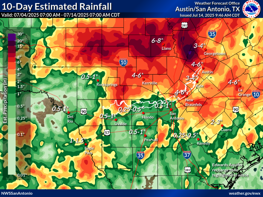
The National Weather Service (NWS) extended its flood watch until 9 p.m. Tuesday for several areas across Texas, including Kerrville.
The watch encompassed the Texas Hill Country, Edwards Plateau, I-35 corridor and the Rio Grande Plains.
"An upper-level disturbance over Central Texas combined with abundant moisture are likely to bring another chance for heavy rain across parts of the Southern Edwards Plateau and Hill Country. Rain rates of 1 to 2 inches per hour could lead to flooding over areas affected by earlier heavy rain," the NWS explained.
"Additional rainfall of 1 to 2 inches with isolated totals up to 4 inches is possible," forecasters added.
Some highwater rescues were performed around Montell, Texas, in Uvalde County on Tuesday, including one involving a semi-truck being washed off a road.
Five feet of water closed one road near Camp Wood in Real County. Lost Maples State Park reported more than a foot over a road.
Flood warnings were issued for the Nueces and Frio rivers in Uvalde County until late Tuesday night or early Wednesday morning due to minor to moderate flooding.
Search efforts in Kerr County were once again stalled Monday due to ongoing rain but they resumed on Tuesday.
The City of Eagle Pass issued mandatory evacuation orders for areas in Quemado and Normandy on Monday.
The City of Laredo activated its Emergency Operations Center before issuing a flood warning for the Rio Grande from Wednesday morning through Thursday evening.
Water levels were expected to enter minor flood stage at Laredo's International Bridge Two. River levels may reach 16 feet at the Columbia-Solidarity Bridge.
Officials said conditions may evolve rapidly depending on continued rainfall upstream.

Emergency management officials this week tried to work around the patchwork of flood watches and warnings — suspending work in some areas and resuming work in others — as one storm after another drenched different parts of Kerr County, sparking harrowing evacuation orders for an exhausted Hill Country community.
Some drier weather was expected to begin after Tuesday night for much of the Hill Country and San Antonio.
The search and recovery efforts across the Hill Country will at least benefit from milder temperatures. Highs in the low 90s are in the forecast for Kerr County through the rest of the week. Highs of 100 or more are not uncommon this time of year.
Copyright 2025 Texas Public Radio


